Learn about different map projections, their uses, and how they distort our world. Essential knowledge for anyone working with maps.
Understanding Map Projections: A Complete Guide
Map projections are mathematical transformations that convert the three-dimensional Earth into a two-dimensional map. Since the Earth is a sphere and maps are flat, some distortion is inevitable in any projection.
Why Do We Need Map Projections?
The fundamental challenge in cartography is representing a spherical surface on a flat plane. This is mathematically impossible without distortion, similar to trying to flatten an orange peel - it will always tear or stretch.
Types of Map Projections
1. Cylindrical Projections
Cylindrical projections wrap the Earth in a cylinder and project it onto a flat surface.
Mercator Projection:
- Preserves angles and directions
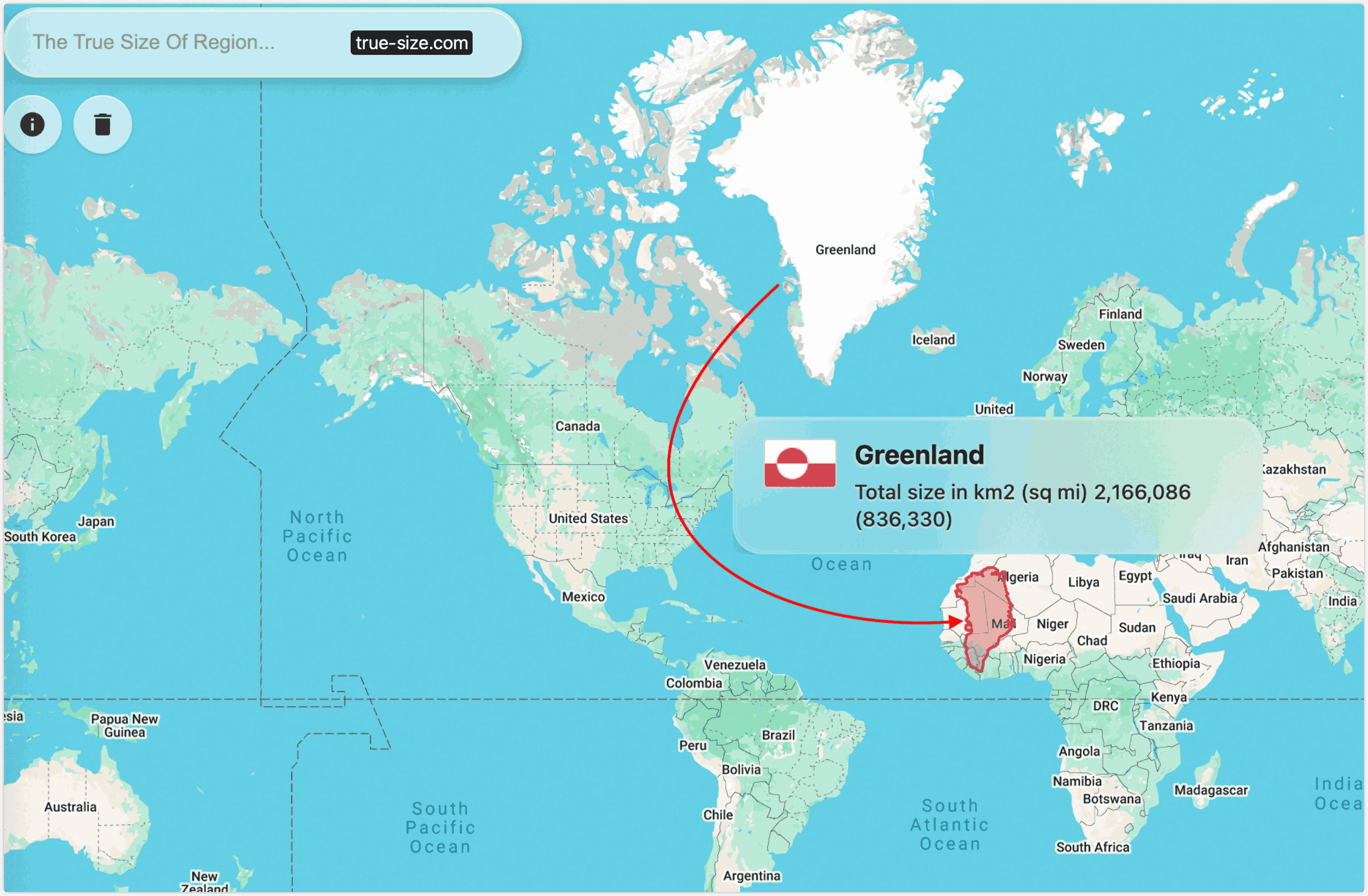
- Distorts size, especially near poles
- Used for navigation
- Greenland appears larger than Africa (but isn't!)
Miller Projection:
- Modified Mercator with less polar distortion
- Better for world maps
- Still has size distortions
2. Conic Projections
Conic projections use a cone to project the Earth's surface.
Albers Equal Area:
- Preserves area relationships
- Good for thematic maps
- Distorts shapes
Lambert Conformal:
- Preserves angles locally
- Used for aeronautical charts
- Distorts area
3. Azimuthal Projections
Azimuthal projections project the Earth onto a plane.
Orthographic:
- Shows Earth as seen from space
- Great for visualization
- Significant distortion at edges
Stereographic:
- Preserves angles
- Used for polar regions
- Distorts area
Choosing the Right Projection
The choice of projection depends on your purpose:
| Purpose | Best Projection | Why |
|---|---|---|
| Navigation | Mercator | Preserves directions |
| Area comparison | Equal Area | Preserves size relationships |
| General reference | Robinson | Balanced distortion |
| Polar regions | Azimuthal | Minimal distortion |
Common Misconceptions
- **"Mercator is the most accurate"** - It's good for navigation but terrible for size comparison
- **"All projections are equally valid"** - Each has specific strengths and weaknesses
- **"Equal area means no distortion"** - It only preserves area, not shape or distance
Modern Solutions
Interactive Maps Web-based mapping allows users to: - Switch between projections - Zoom to minimize distortion - Use 3D globes for accurate representation
Multiple Views Many modern atlases show: - Different projections for different regions - Specialized projections for specific purposes - 3D representations where appropriate
Best Practices
- **Choose projection based on purpose**
- **Always indicate which projection you're using**
- **Consider your audience and their needs**
- **Use multiple projections when possible**
- **Educate users about distortions**
Conclusion
Understanding map projections is crucial for anyone working with geographic data. No single projection is perfect for all purposes, but knowing the strengths and weaknesses of different projections helps you choose the right one for your specific needs.
Remember: Every flat map is a compromise. The key is understanding what you're compromising and why.
For more information about map projections and their applications, visit our interactive map tool at true-size.com.